

Mumbai, the financial capital of India, along with several other cities across Maharashtra, has been witnessing relentless heavy rainfall over the past 48 hours, triggering widespread waterlogging, severe traffic congestion, disrupted flight operations, and an official high tide alert. The India Meteorological Department (IMD) has forecasted continued rainfall accompanied by thunderstorms and gusty winds, urging citizens to remain indoors unless absolutely necessary.
Mumbai: Flights Delayed, Cars Submerged, and Streets Underwater
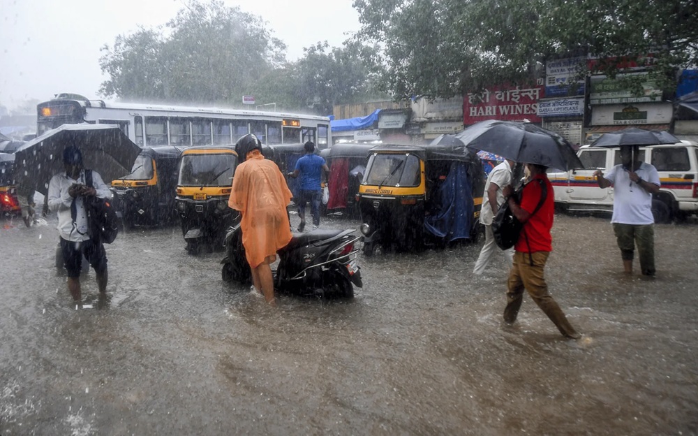
As the rain clouds loomed over Mumbai since early Monday morning, the city quickly found itself grappling with severe waterlogging. Major roads across the city—especially in low-lying areas like Dadar, Sion, Kurla, Andheri East, and Chembur—turned into virtual rivers, bringing vehicular movement to a crawl. Disturbing visuals emerged from parts of Mumbai where cars were seen partially or fully submerged, especially in underpasses and narrow lanes.
Flight operations at Chhatrapati Shivaji Maharaj International Airport were severely affected. Multiple incoming and outgoing flights faced delays of up to 90 minutes due to low visibility and water accumulation on runways. According to airport authorities, over 24 flights were delayed and 6 were diverted to nearby airports like Pune and Ahmedabad. Passengers were advised to check their flight status before heading to the airport.
In addition to the air traffic disruption, the local train network, often called Mumbai's lifeline, also experienced delays. Waterlogged tracks and overhead wire faults led to cancellations and slow movement on the Central and Western lines. Commuters at CST, Dadar, and Thane were seen stranded for hours amid the chaos.
High Tide Warning Issued
The IMD has issued a high tide alert in Mumbai, warning that sea levels are expected to rise to 4.87 meters during peak hours, especially dangerous due to simultaneous heavy rains. The Brihanmumbai Municipal Corporation (BMC) has deployed pumping stations and emergency response teams across vulnerable zones to tackle the dual threat of rainfall and high tide.
Citizens living in coastal or low-lying areas have been urged to stay indoors and avoid sea-facing promenades such as Marine Drive, Worli Seaface, and Juhu Beach. The BMC has also suspended outdoor school activities and urged offices to allow employees to work from home wherever feasible.
Pune: Urban Flooding and Thunderstorms
In Pune, incessant rainfall since late Sunday night has led to urban flooding in several parts of the city, including Kothrud, Erandwane, Hadapsar, and Vishrantwadi. The city's stormwater drainage system was overwhelmed, causing knee-deep water levels on key roads and bylanes.
Thunderstorms accompanied by lightning strikes and gusty winds were reported in the outskirts of Pune, including Pimpri-Chinchwad and Hinjewadi, which led to temporary power outages in many residential areas.
The Pune Municipal Corporation (PMC) activated emergency helplines and rescue teams to assist residents in flood-affected areas. Fortunately, no casualties were reported, but several two-wheelers and cars were damaged due to falling branches and water ingress.
Nashik and Nagpur: Overflowing Rivers and Heavy Downpour
Nashik, known for its proximity to the Godavari river, reported rising water levels in several local water bodies. The heavy rainfall over the past 36 hours has caused the Godavari and Darna rivers to swell, prompting local authorities to release water from the Gangapur dam as a precautionary measure.
Several villages on the outskirts of Nashik were put on flood watch, and educational institutions were advised to shift to online classes for the next two days.
In Nagpur, the orange city recorded more than 80 mm of rain in 24 hours, leading to waterlogging in prominent areas like Sitabuldi, Dharampeth, and Sadar. Nagpur’s civic administration reported multiple complaints of water seepage into homes and housing societies, particularly in low-lying zones. Thunderstorms also caused brief power interruptions in many sectors.
Other Affected Cities: Aurangabad, Kolhapur, and Ratnagiri
Aurangabad experienced moderate to heavy showers coupled with strong winds. The city’s historic monuments and tourist sites were temporarily closed as a safety measure. Low-lying neighborhoods like CIDCO and Osmanpura reported localized waterlogging.
Kolhapur, located near the Western Ghats, witnessed intense rainfall for the third consecutive day. The Panchganga river’s water level has been steadily rising, though it remains below the danger mark. However, authorities are keeping a close watch and have urged people not to venture near riverbanks.
In the Konkan region, Ratnagiri and Sindhudurg districts saw extremely heavy rains. The Meteorological Department has predicted rainfall exceeding 200 mm in isolated areas, warning of landslides in hilly terrain and reduced visibility on the Mumbai-Goa highway. Fishing activities have been suspended, and residents have been advised to avoid traveling unless absolutely necessary.
IMD Forecast and Government Response
The India Meteorological Department has placed most of Maharashtra under an orange alert, indicating the likelihood of extremely heavy rainfall in isolated places. The monsoon trough remains active over the state, fueled by a cyclonic circulation over the Arabian Sea.
Chief Minister Eknath Shinde chaired an emergency meeting and instructed district collectors to remain on high alert. The National Disaster Response Force (NDRF) has been deployed in flood-prone areas across the state, including Palghar, Thane, Nashik, and Pune.
Precautionary Measures for Citizens
Authorities have issued the following advisory:
Avoid unnecessary travel, especially in flood-affected or low-lying areas.
Check weather updates and flight/train status before stepping out.
Stay away from coastal zones during high tide hours.
Keep emergency supplies, power banks, and essential medicines ready.
Follow updates from official handles like IMD, BMC, and disaster management cells.
As Maharashtra continues to battle this spell of monsoon fury, timely alerts and community cooperation remain key to minimizing risks and ensuring public safety. With more rain forecasted over the next 48 hours, residents are urged to stay vigilant and prioritize safety above all.